
Look up at the night sky as people have done since the beginning of time. Some of those bright dots are planets. Others are bright stars. There are constellations to pick out if you know where to look.
Night Sky makes it easy to identify the planets and constellations on a clear, easy to read display. The example screen below shows the view facing south from your location. East is to your left, west is to your right. The center of the sky, above you, is marked with a cross at the top of the screen. A 45 degree angle (half way between the horizon and vertical) is marked by the circle.

To look east, tap the lower left corner of the screen and the view will rotate. Now you see the sky in that direction. Tap again for north and again for west.
Tap the lower right corner to rotate the view in a clockwise direction.
If you load Night Sky during the day, the initial view will show the sky not long after sunset. If it is already night, the initial view is the sky as seen from your location right now.
Tap the upper right corner of the screen to advance the view by one hour.
Tap the upper left corner of the screen to look at the sky an hour earlier.
The last view shown before you quit the web application will be saved for offline viewing (iPhone OS 3.0+ only). This is handy if you are taking your iPhone or iPod outside to a location with no internet connection.
You can drag the view around the screen to see parts of the sky that are off screen.
Tap the command bar at the top of the screen to scroll up to the settings.
If you are using an iPhone and you have enabled Location Services in the settings, Night Sky will read the GPS to determine your exact location.
If you do not have a GPS, or if you have disabled Location Services, Night Sky will determine your location from your internet connection. In most cases this will be accurate enough for the sky view.
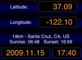
If you find that the location is not accurate, you may enter a new latitude and longitude into the input boxes.
Tapping on the words Latitude or Longitude will show you which method was used to determine your location and allow you to check on a map to see if it is close enough. Within a degree or two is fine.
The date and time shown are used to create the sky map. To see the sky on a different date or at a different time, enter a new date and time in the boxes.

To save the Night Sky app to the home screen, return to the webapp page and press the large + at the bottom of the screen. Select Add to Home Screen.
![]()
![]()
Night Sky is designed to work with no internet connection just like a purchased application. When offline, you will only have access to the lask sky map viewed. If you would like more maps to be saved for offline viewing, please let me know.
The sky maps are from heavens-above.com created by Chris Peat, Heavens-Above GmbH. Thank you for sharing, Chris. His web site will help you spot the ISS and other satellites, or to see an Iridium Flare. You should take a look.
Credits
Night Sky uses geoPlugin.com to determine your location and earthtools.org to calculate sunrise and sunset times.